If you have ever walked from the Saddlebow Roundabout on the A47 towards the Saddlebow Industrial Estate on the edge of King’s Lynn, you may have noticed this curious little concrete bridge over nothing.
This one could count as a secret, because if you only go over it in a car you’ll never notice it, and if you do notice it you might not guess it is a railway bridge. But it’s actually the closest thing we have to a remnant of South Lynn station itself.
I’ll avoid a full history of South Lynn station and the M&GN, because that is better done elsewhere. In short, South Lynn had a sprawling station roughly where this bridge is. It was part of the Midland & Great Northern Joint Railway, a network of lines reaching Great Yarmouth to the east, and Peterborough and Bourne to the west. South Lynn station was roughly in the M&GN’s centre.
The entire system closed in 1959, including South Lynn station. But much of its site was used as a goods yard until 1994, with the tracks being lifted in 1995.1 This yard primarily served the British Sugar beet factory that was (more or less) on the site of today’s giant Palm Paper factory.
Some of South Lynn’s platforms survived through the 1960s. Most of the original South Lynn station was obliterated by the construction of the A47 bypass from Hardwick Roundabout to Pullover Roundabout in the early 1970s.2 The A47 bridge over the Ouse is on the site of the M&GN bridge over the Ouse, the A47 tracks the route of the M&GN over to Pullover Roundabout, and from there the A17 follows the route for some considerable distance. So if you ever wondered why this section of the A17 is so straight, now you know!
The current High Road at the location of this bridge existed back in M&GN times; there was a much larger bridge that crossed the M&GN more or less here. A slight realignment of High Road when the Saddlebow Roundabout was constructed means that the extant bridge is about 20 metres to the west of the old one, as you can see in the map below with the old and new locations marked on a map overlaid on satellite imagery.3
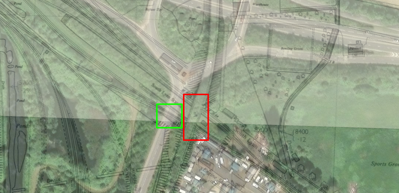
As said, nothing at all remains of South Lynn station itself; as the map above shows, its site is buried in the embankments of the A47 and under the Saddlebow Roundabout. This bridge was constructed to allow freight traffic from Harbour Junction into the goods sidings that were here until the mid-1990s.
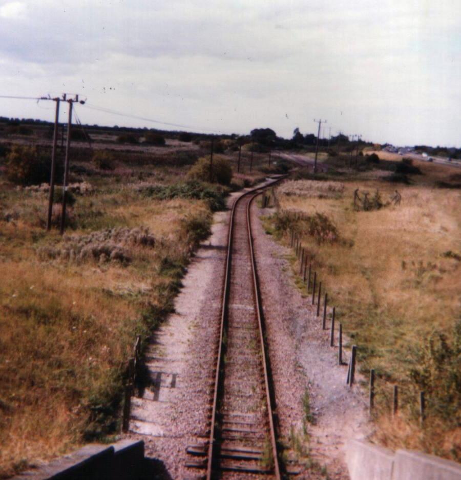
A photograph by Paul Miller below shows what this single-track goods line would have looked like in, most likely, the mid-1980s. This view is looking west towards the Great Ouse.
Let’s have a look at an older view at former-track level from 2007.
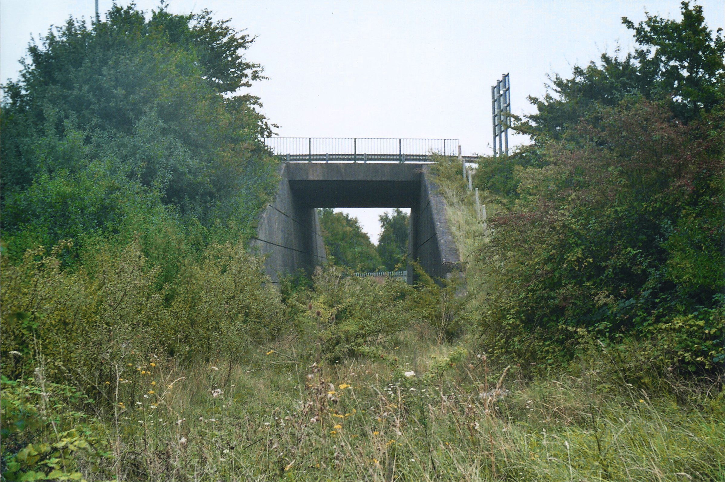
I don’t think you could easily take that photo today; the grassy slope down the bank on the right hand side has been rather overtaken by trees and vegetation these days, and I’m somewhat more conscious of my mortality than I was at the age of 24.
For an even older view, you can see this rare photo, from the outstanding East Anglian Railway Archive site, of a diesel multiple unit visiting this location on a rail tour in 1980 (you can see the concrete bridge in the background):
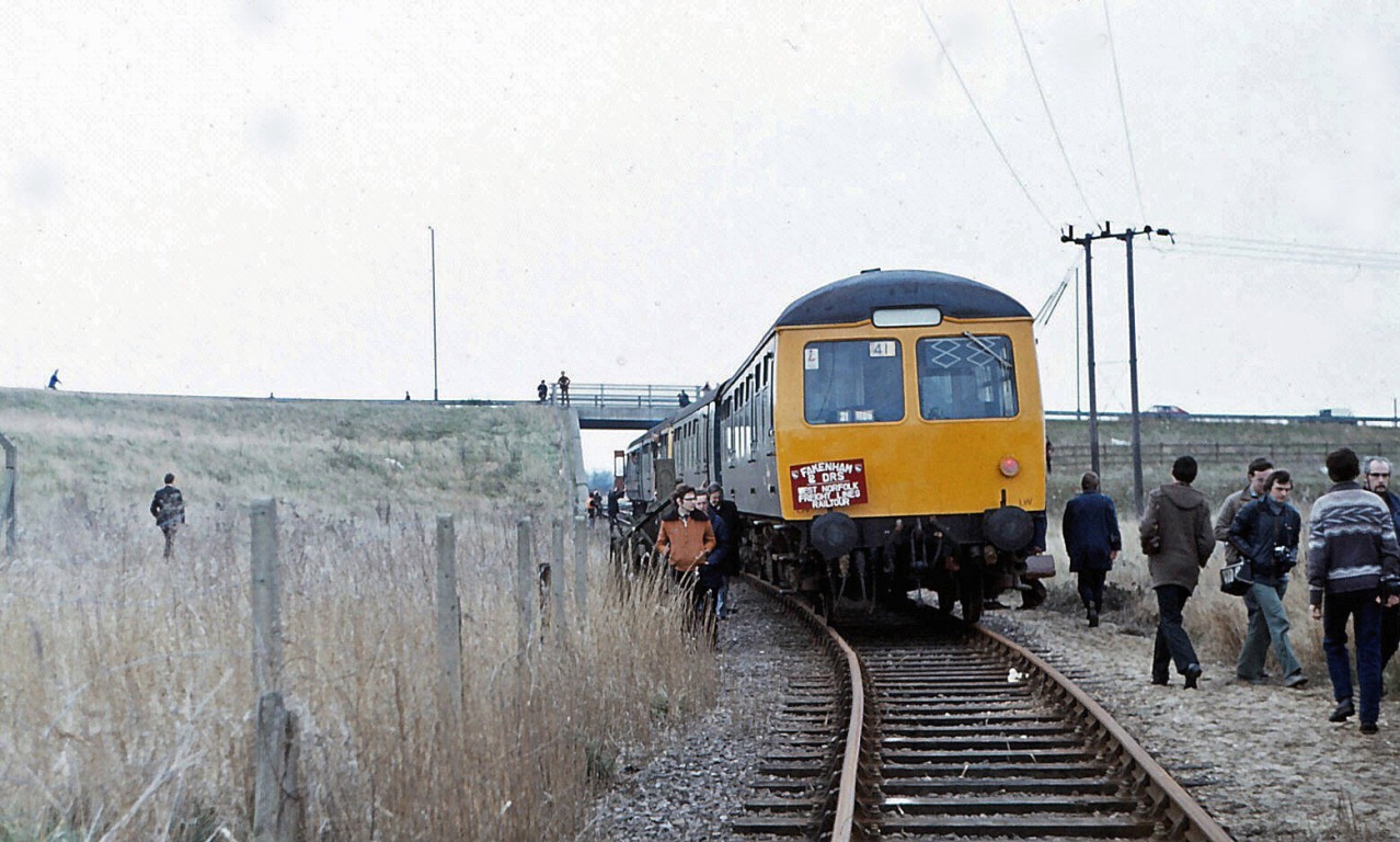
That’s not a view we’ll see repeated and not just because there’s unlikely to ever be a railway track here; I doubt railtours allow people to jump out of the train and wander around an active freight yard these days!
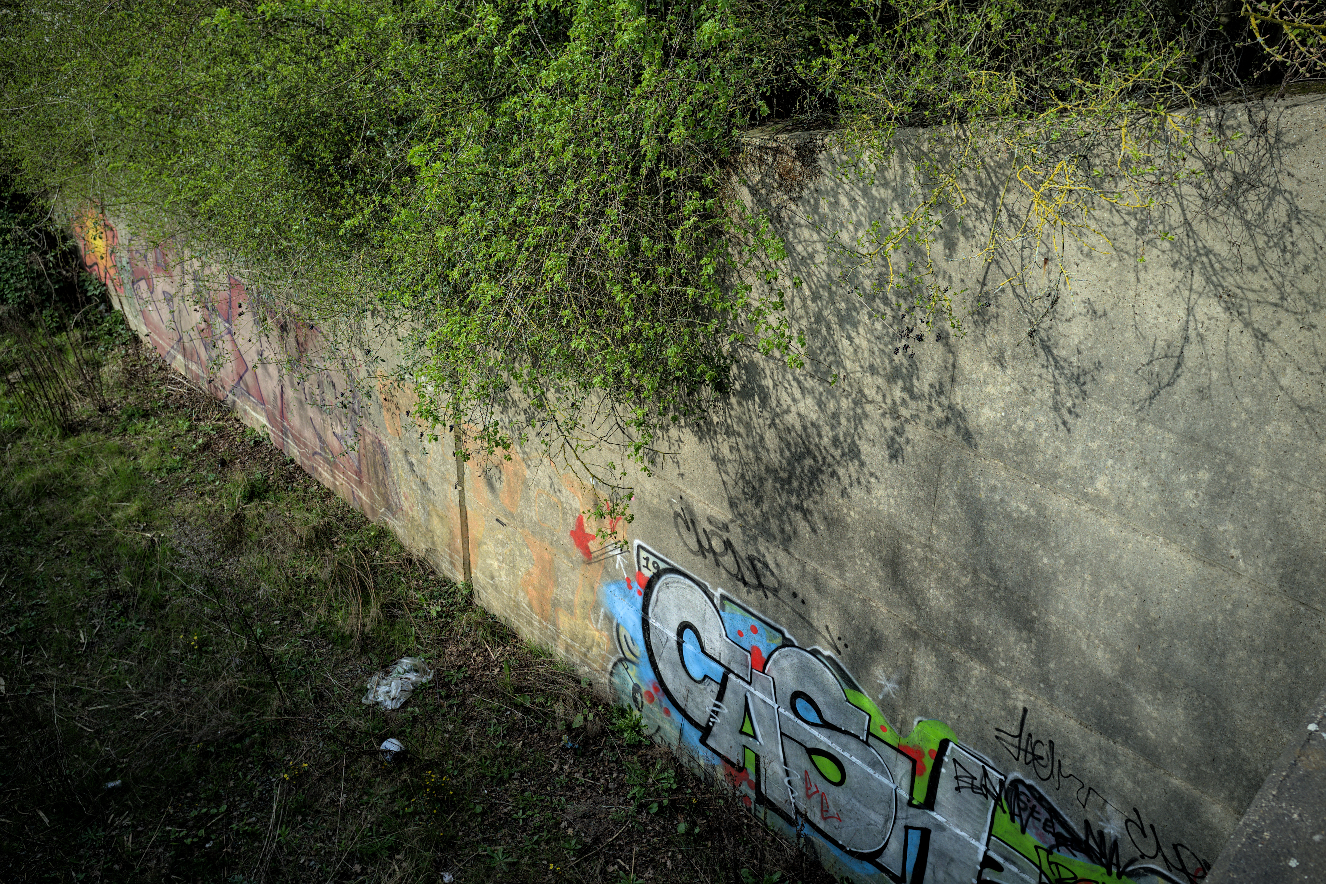
Somewhat less averse to the peril of walking down the wing walls of this bridge is the author of the Norfolk’s Disused Railways site, and so I will use his photo below of the other side of the bridge.
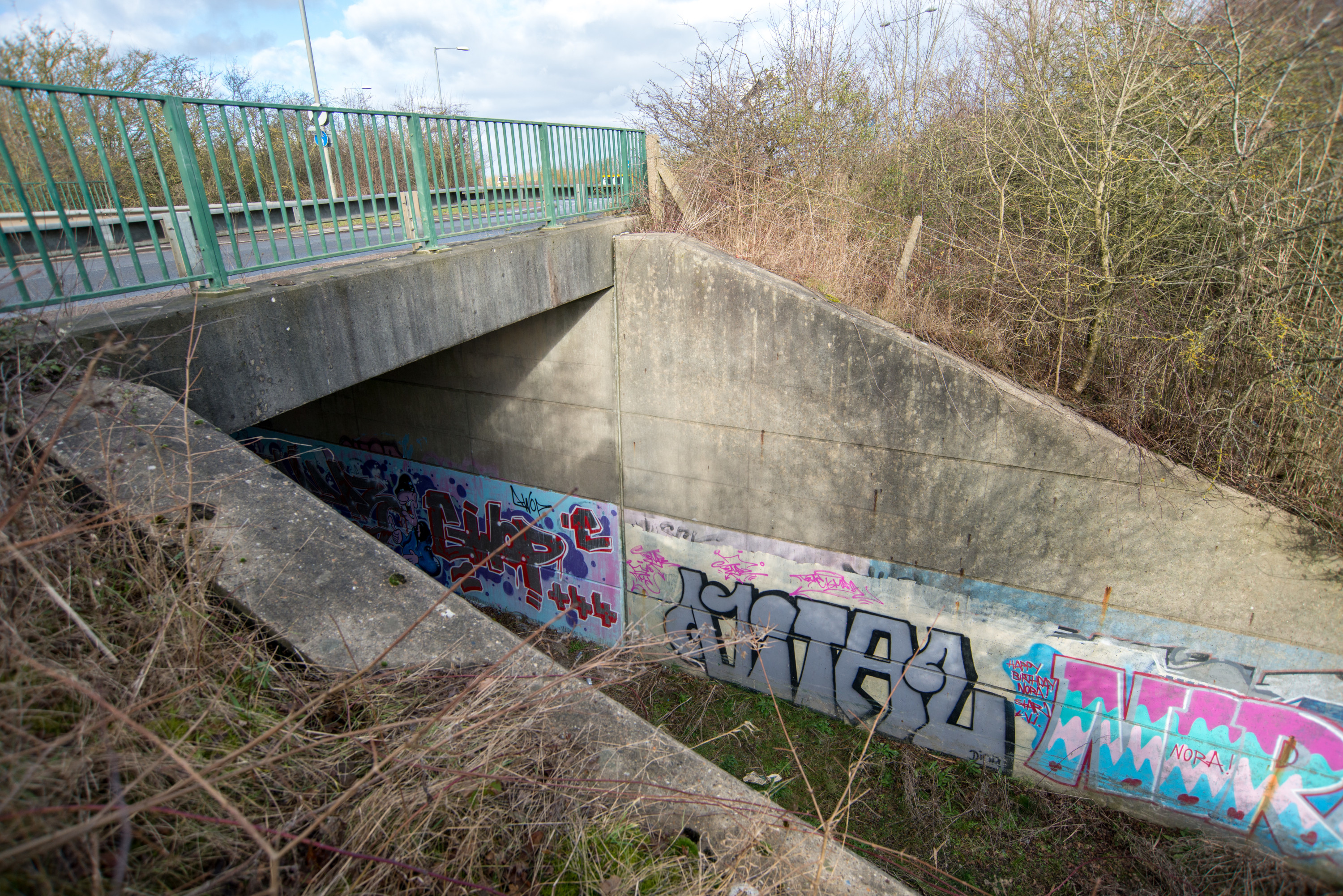
One could complain about the graffiti here. I am less inclined to do that. It doesn’t make the giant concrete walls any more ugly, as graffiti would if targeted at Victorian ironwork and engineering bricks. Perhaps we will see it as unthinkable in a hundred years when (maybe if) we look back on remnants of the 1960s with the same reverence as we do the remnants of the Victorian era. For now I’m more inclined to see it as part of the bridge’s life, and as just another use that it has been put to.
I’ll expect this bridge to be around for a while; not because it is likely to be useful for railway purposes ever again, but because it’d be awfully hard to demolish, and its many-feet-thick concrete construction means that this is unlikely to be necessary for a long time.
And now an aside, because asides are something I excel at, and all the better if those asides are much longer than the thing I initially intended to write about.
In 2024 local media outlets reported on plans to re-open the station at South Lynn; not because it is even slightly likely to happen, but because they needed something to report on. This was the first time I have seen such a suggestion about South Lynn. But as someone who likes looking at the history of such things I see this a lot in reporting of alleged plans and proposals to open the King’s Lynn to Hunstanton branch.
First, you need like two people to call themselves an action group and to say it’s a good idea, and that gets reported as “proposals”. Sometimes those two people tell some local government authority that opening the line would be a good idea. The local government responds that there is no business case for it and there isn’t any money to do it, but because governments are allergic to language they will say something like “it could be considered, if a clear business case were made for it and funding was made available”. This is reported along the lines of “Lynn to Hunstanton line could reopen”, with the reporter receiving a substantial bonus for getting the words “back on track” into the headline. And of course nothing happens, because there was no real plan and no money to pay for it.
This has repeated itself every few years since at least the early 1980s! We can’t even blame the decline of print and the miserable economics of online advertising for it.
So it was with the proposed re-opening of South Lynn. There are about six people whose shared hobby is generating vague ideas for moving economic activity to places they think deserve it more than other places, and telling other people to pay for and implement those ideas and also to work out any details of what that would look like. Those people are called an “organisation” or “coalition”, which is technically correct.
Those people suggested that some buildings should be built somewhere south of King’s Lynn, so that economic activity can be moved into them, and this is called a “strategy” to build a “powerhouse”. They also said that those buildings would be even better with a railway station.
The sum of this is reported as "Major plans to create new railway station between south of King’s Lynn and West Winch", and it is implied that the closed South Lynn station would be a great location for a station south of King’s Lynn. “South” and “Lynn” are right there in the name after all!
Apparently no reporter bothered to look at a map to see that the old South Lynn station is more than half a kilometer west of the current Fen Line, and that the Fen Line is itself a kilometer west of any of the developments in West Winch which such a station was “planned” to serve. Or maybe they did, but decided that “People have more ideas than thoughts” wasn’t much of a headline or a story.
And I suppose me writing about this fact makes me a part of the problem too! I’m telling you all about something that isn’t going to happen, just one meta-level up from the reporting I’m complaining about! Still, writing this gave me something to do on a Monday morning before work, just like local news journalism keeps people with media degrees off the streets. Just imagine the trouble they’d cause.
Sources & more reading
- Norfolk’s Disused Railways has plenty about this area with lots of rare views on a page about South Lynn.
- NHER: 63569 from the Norfolk Heritage Explorer.
-
Nick Youngman’s notebooks, from when he worked at Lynn Junction signal box, has the last train running on this section as 31205 collecting molasses tanks, on the 21st of July 1994, following the last firing of the beet factory on the 1st of March, 1994. His notebooks name the date that track lifting began in these sidings, carried out by the scrap merchant Derek Miller, as the 26th of March 1995. ↩︎
-
I have seen the date for the opening of the bypass variously claimed as 1973 or 1975. The Lynn News & Advertiser from Tuesday 20 May 1975 anticipates the opening as coming in Thursday of that same week (22 May) – though this doesn’t tell us when the station was demolished, or this bridge constructed. ↩︎
-
Map courtesy of the National Library of Scotland. ↩︎